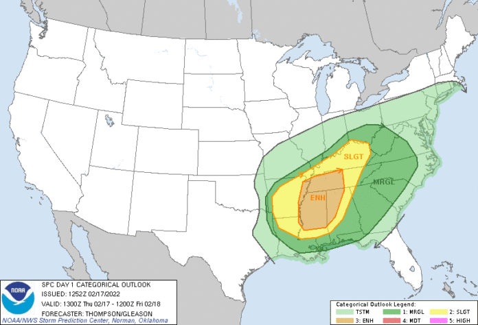
Here is what we know and what to expect according to the NWS about today’s Severe weather event. We will be updating throughout the day as details become available. You can also keep up to date with our Live radar and Live traffic map:
National Weather Service Nashville TN
216 AM CST Thu Feb 17 2022

TNZ005>011-023>034-056>066-075-077>080-093>095-180300-
/O.EXT.KOHX.WI.Y.0002.220217T0900Z-220218T0300Z/
Stewart-Montgomery-Robertson-Sumner-Macon-Clay-Pickett-Houston-
Humphreys-Dickson-Cheatham-Davidson-Wilson-Trousdale-Smith-
Jackson-Putnam-Overton-Fentress-Perry-Hickman-Lewis-Williamson-
Maury-Marshall-Rutherford-Cannon-De Kalb-White-Cumberland-Bedford-
Coffee-Warren-Grundy-Van Buren-Wayne-Lawrence-Giles-
Including the cities of Dover, Clarksville, Springfield,
Hendersonville, Gallatin, Goodlettsville, Lafayette, Celina,
Byrdstown, Erin, Tennessee Ridge, Waverly, New Johnsonville,
McEwen, Dickson, Ashland City, Kingston Springs, Nashville,
Lebanon, Mount Juliet, Hartsville, Carthage, South Carthage,
Gordonsville, Gainesboro, Cookeville, Livingston, Jamestown,
Allardt, Linden, Lobelville, Centerville, Hohenwald, Franklin,
Brentwood, Columbia, Lewisburg, Murfreesboro, Smyrna, La Vergne,
Woodbury, Smithville, Sparta, Crossville, Shelbyville, Tullahoma,
Manchester, McMinnville, Altamont, Coalmont, Spencer, Clifton,
Waynesboro, Lawrenceburg, and Pulaski
216 AM CST Thu Feb 17 2022

...WIND ADVISORY NOW IN EFFECT UNTIL 9 PM CST THIS EVENING...

* WHAT...South winds 15 to 30 mph with gusts up to 45 mph
  expected.

* WHERE...All of Middle Tennessee.

* WHEN...Until 9 PM CST this evening.

* IMPACTS...Gusty winds could blow around unsecured objects.
  Tree limbs could be blown down and a few power outages may
  result.

PRECAUTIONARY/PREPAREDNESS ACTIONS...

Use extra caution when driving, especially if operating a high
profile vehicle. Secure outdoor objects.

&&

$$
Hazardous Weather Outlook
Hazardous Weather Outlook
National Weather Service Nashville TN
348 AM CST Thu Feb 17 2022

TNZ005>011-023>034-056>066-075-077>080-093>095-181130-
Stewart-Montgomery-Robertson-Sumner-Macon-Clay-Pickett-Houston-
Humphreys-Dickson-Cheatham-Davidson-Wilson-Trousdale-Smith-Jackson-
Putnam-Overton-Fentress-Perry-Hickman-Lewis-Williamson-Maury-
Marshall-Rutherford-Cannon-De Kalb-White-Cumberland-Bedford-Coffee-
Warren-Grundy-Van Buren-Wayne-Lawrence-Giles-
348 AM CST Thu Feb 17 2022

This Hazardous Weather Outlook is for Middle Tennessee.

.DAY ONE...Today and tonight.

Severe weather event expected today. Severe storms are likely to
develop in the afternoon and early evening. These storms may
produce either straight-lined winds and/or spinup tornadoes.

Additionally, gradient winds today are likely to gust to around
45mph at times.

.DAYS TWO THROUGH SEVEN...Friday through Wednesday.

Heavy rainfall will be possible Monday through Wednesday at times.

.SPOTTER INFORMATION STATEMENT...

Spotter activation may be needed. Please relay any
information about observed severe weather to the NWS while following
all local, state, and CDC guidelines.
The primary threat for supercells in the warm sector may be delayed
   until mid afternoon across the Mid South, with broken bands of
   storms/embedded supercells along and ahead of the front spreading
   eastward into AL/Middle TN this evening.  Despite the rather modest
   buoyancy and lapse rates expected, very strong low-level shear
   (curved hodographs with 300-500 m2/s2 0-1 km SRH) and effective bulk
   shear of 50-60 kt will favor supercells, and a storm or two could
   produce a strong tornado (in addition to damaging winds) this
   afternoon into this evening across northeast MS/northwest AL and
   adjacent areas of TN.


