Tennesseans are asked to batten down the hatches in advance of non-thunderstorm wind gusts of up to 50 mph on Wednesday and the chance of severe weather Wednesday afternoon into the evening.
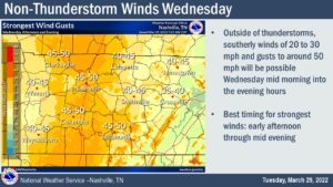
Loose lawn furniture and anything that might either blow away or topple over should be secured before heavy winds kick up early tomorrow morning.
Before we look in-depth at everyhting from the NWS, here are the highlights:
- Wind Advisory goes into effect Wednesday morning at 9:00 a.m. Winds of 20-25 mph can be expected tonight.
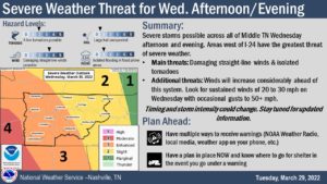
- Severe weather is expected to be approaching our area around your afternoon drive home and for middle Tennessee into the early evening.
- Besides the heavy winds and possible tornadoes, expect heavy rain to fall in a short period of time causing localized flooding and issues on our roads.
We will update as needed and as always bookmark your Close To Home Weather Page. You can find it here. For Live Local radar, watches, and warnings.
Today
A 10 percent chance of showers after 5pm. Mostly cloudy, with a high near 83. Windy, with a south wind 15 to 20 mph increasing to 25 to 30 mph in the afternoon. Winds could gust as high as 50 mph.
1Wind Advisory
URGENT - WEATHER MESSAGE
National Weather Service Nashville TN
146 PM CDT Tue Mar 29 2022

TNZ005>011-023>034-056>066-075-077>080-093>095-301200-
/O.CON.KOHX.WI.Y.0006.220330T1400Z-220331T0600Z/
Stewart-Montgomery-Robertson-Sumner-Macon-Clay-Pickett-Houston-
Humphreys-Dickson-Cheatham-Davidson-Wilson-Trousdale-Smith-
Jackson-Putnam-Overton-Fentress-Perry-Hickman-Lewis-Williamson-
Maury-Marshall-Rutherford-Cannon-De Kalb-White-Cumberland-Bedford-
Coffee-Warren-Grundy-Van Buren-Wayne-Lawrence-Giles-
Including the cities of Dover, Clarksville, Springfield,
Hendersonville, Gallatin, Goodlettsville, Lafayette, Celina,
Byrdstown, Erin, Tennessee Ridge, Waverly, New Johnsonville,
McEwen, Dickson, Ashland City, Kingston Springs, Nashville,
Lebanon, Mount Juliet, Hartsville, Carthage, South Carthage,
Gordonsville, Gainesboro, Cookeville, Livingston, Jamestown,
Allardt, Linden, Lobelville, Centerville, Hohenwald, Franklin,
Brentwood, Columbia, Lewisburg, Murfreesboro, Smyrna, La Vergne,
Woodbury, Smithville, Sparta, Crossville, Shelbyville, Tullahoma,
Manchester, McMinnville, Altamont, Coalmont, Spencer, Clifton,
Waynesboro, Lawrenceburg, and Pulaski
146 PM CDT Tue Mar 29 2022

...WIND ADVISORY REMAINS IN EFFECT FROM 9 AM WEDNESDAY TO 1 AM
CDT THURSDAY...

* WHAT...South winds 20 to 30 mph with gusts up to 50 mph
  expected.

* WHERE...All of Middle Tennessee.

* WHEN...From 9 AM Wednesday to 1 AM CDT Thursday.

* IMPACTS...Gusty winds could blow around unsecured objects.
  Tree limbs could be blown down and a few power outages may
  result.

* PRECAUTIONARY/PREPAREDNESS ACTIONS...

PRECAUTIONARY/PREPAREDNESS ACTIONS...

Use extra caution when driving, especially if operating a high
profile vehicle. Secure outdoor objects.
Update on Wednesday storms:
There hasn’t been much of a change in the forecast for our area for tomorrow. The main threats are still damaging winds and isolated tornadoes. We think these threats are highest for areas west of I-65, but all of Middle TN could see severe weather.
Even before storms arrive there will be very strong wind gusts out of the south. Now, yes, right now, is the time to start securing loose outdoor items. Gusts up to 50 mph before storms arrive, when it’s still sunny outside, can certainly make a mess of that cute outdoor living space you’ve arranged. And we don’t want that! More importantly, lightweight outdoor objects could actually cause damage to windows and cars if left unsecured with the winds we’re expecting tomorrow. So strap ’em down. These gusty winds may also make travel difficult for high profile vehicles and could cause some tree damage with the highest gusts.
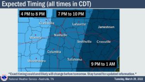
Now let’s talk about storm timing. Storms could move across the Tennessee River as early as 4PM and continue moving east to the Cumberland Plateau through 1AM. Unfortunately, this does mean that it will be dark when storms are impacting at least a portion of our area. Keep those weather radios turned on and your phone volume turned up in case a warning is issued while you sleep. See the map below for more information on timing.
As our highest resolution models come in tonight, our forecast details could change. So stay tuned for more updates here, on Twitter, or at www.weather.gov/nashville.


